
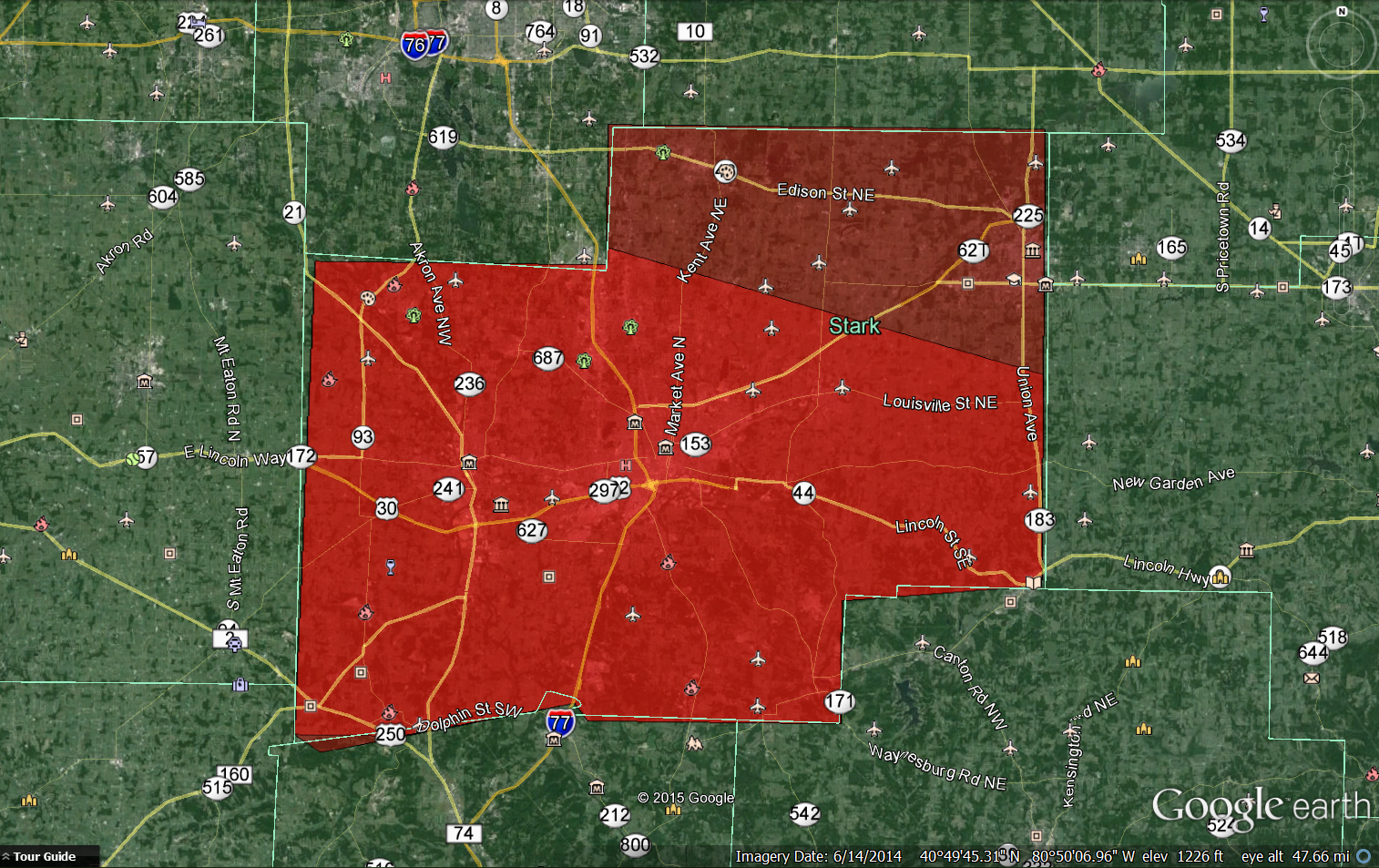
This image is comprised of two .kml files uploaded to Google Earth that are associated with the two tornado warnings issued for the storm on June 18th. The first tornado warning, issued at 7:09pm, is displayed as the bright red polygon. When the second warning, corresponding to the Uniontown/Hartville tornado, was issued at 7:15pm, the warning polygon encompassed the whole county; both the dark red and bright red regions above.
Though Stark County, located in northeastern Ohio, generally receives a few tornado warnings each year, there has not been a confirmed tornado touchdown within county lines since August 9th, 2007. In that storm system, which is very similar to the one from last week that I am about to discuss, microvorticies along a strengthening bow echo produced a weak EF0 tornado in Massillon, Ohio, just a few miles away from Uniontown.
In similar fashion, last month a strengthening bow echo moved through the area, and two microvorticies in particular were watched closely by the National Weather Service in Cleveland, Ohio. Both of these, which will be discussed in greater detail soon, resulted in a tornado warning, and the NWS later confirmed an EF1 tornado had been produced by the northernmost of these microvortices, touching down between Uniontown and Hartville, Ohio. This tornado ripped apart trees and damaged the roofs of several houses and barns along a nine mile long path. Using data from the National Climatic Data Center (NCDC), I have posted some images below of the resulting reflectivities and velocities as the storm progressed through the county.
6:55pm

Storm Base Reflectivity at 6:55pm

Storm Base Velocity at 6:55pm
The first severe damage that this storm caused was witnessed in Summit County, not too far from the Portage Lakes area. Looking at the radar imagery from 22:55 UTC (6:55pm EST), there is a nice appendage near where the damage appeared, but any rotation is broad. There is, however, a strong pocket of wind in excess of 70kts at the lowest sampling level, and the NWS attributed the damage to straight line winds.
7:05pm

Storm Base Reflectivity 7:05pm

Storm Base Velocity 7:05pm
Within about ten minutes, the storm moved into stark county. In the reflectivity image, it is clear that there is a hook echo entering extreme northwestern Stark County. Though the rotation is not very intense, the National Weather Service office in Cleveland, Ohio issued a tornado warning. This pocket of rotation was not the only region of the storm where damaging winds were a threat, for the storm began to bow out just east of the rotating microvortex. In the velocity image, I have circled the microvortex (it is not as deep or strong as a mesocyclone should be) and have outlined the gust front at the leading edge of the bowing section. Furthermore, I was able to capture a nice video of the arcus cloud associated with this gust front and have embedded this video here too.
I previously described the appendage in Summit county that had caused some damage around Portage Lakes. This appendage had weakened since the radar loop ten minutes earlier, and was now overshadowed by the hook echo in western Stark county, but this is the appendage that would go on to become tornadic in a short while.
7:10pm

Storm Reflectivity 7:10pm

Storm Base Velocity 7:10pm
By the next radar loop, the hook echo in northwestern Stark County began to weaken, but the appendage now in northern Stark County began to form a well-defined hook echo. By now it is getting ready to move into Uniontown, Ohio where it will drop a tornado between this radar loop and the next one. I first want to address the bright green patch that can be seen in the storm base velocity image. You always hear meteorologists on TV talk about “the bright reds and greens right next to each other” and how that indicates the presence of strong rotation within the storm. Here, it appears as though there is a large swatch of bright green right beside a lot of bright red, which may lead one to think that there is strong rotation here. This is deceiving, however, for that bright green is an error in the radar’s sampling of wind velocities. In this case the winds that are being sampled by the radar are moving so quickly that they do not correspond to any of the colors on the red pallet and therefore are displayed as bright green.It is not, however indicative of strong rotation. Instead, just to the east of the red “hook” of velocities moving away from the radar, there is a patch of gray with some dull green colors in it. This gray and dark green alongside the bright reds is where the rotation is. At first this may not make sense. If winds are that weak, could a tornado really do much damage? The key here is that the storm is moving away from the radar as the radar samples this, and since this image is not storm-relative velocity, the apparent velocity of the inflow winds is much smaller than what it actually is. All this considered, the rotation at this point it is still weak, but the NWS still issued a warning on it.
The other hook echo, located in northwestern Stark County, has weakened by now, as previously mentioned. Some members of Stark County Skywarn reported seeing a wall cloud, but I don’t know if it was reported to have been rotating or not. To my knowledge there was no funnel cloud reported with that hook.
7:15pm

Storm Base Reflectivity 7:!5pm
Storm Base Velocity 7:15pm
Though the tornado warning in western Stark County remained in effect, the hook echo had essentially dissipated. An appendage was still visible, but there was no notable rotation or strong winds. The hook echo in northern Stark County, however, was in full force. There was currently an EF1 tornado striking along a path between Uniontown and Hartville.
7:19pm

Storm Base Reflectivity 7:19pm

Storm Base Velocity 7:19pm
This is when the hook echo is most impressive in my opinion, for the reflectivity shows a very nice hook appendage. This is also when the microvortex appears the most well defined amongst the base velocity images. Nevertheless, the rear-flank downdraft (RFD) is beginning to intensify, which will soon kill microvortex. Furthermore, the storm as a whole will soon begin to bow out, which will help the RFD kill the microvortex.
7:24pm

Storm Base Reflectivity 7:24pm

Storm Base Velocity 7:24pm
By now the tornado is no longer on the ground. The RFD is producing strong surface winds that would cut off any circulation attempting to reach the ground. This RFD is producing a new gust front, which is manifesting itself quite well in both the reflectivity and velocity images. Though the hook echo persists for a few more minutes, it does not produce any more tornadoes. Not visible until the next radar loop is a rear inflow jet that will help this complex evolve into a nice bow echo. As the rear inflow jet intensifies, the storm would soon begin to bow out and quickly move straight for Pennsylvania, producing damaging straight-line winds as it moves along.
