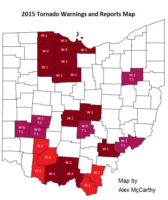
Ohio Tornado Warnings and Confirmed Reports Map
Yesterday was a busy day for the Wilmington, Ohio and Charlestown, West Virginia National Weather Service offices, for both had to issue tornado warnings as a low pressure system made its way through. Wilmington issued their 5th tornado warning of the year, which encompassed Brown, Clinton, and Highland counties (recall that Highland County just had a tornado warning this past Friday). This was the first tornado warning that Brown and Clinton counties have experienced this year, and the second one for Highland. Charlestown issued their 6th tornado warning of the year, encompassing Gallia and Lawrence counties in Ohio, giving both counties their first tornado warning for the year, as well as Cabell County in West Virginia (for the purposes of this map I will not include Cabell county on the map since it is not in Ohio). Neither of these storms produced a tornado, though Wilmington posted this impressive photograph of the mesocyclone from their warned storm on their Facebook page:
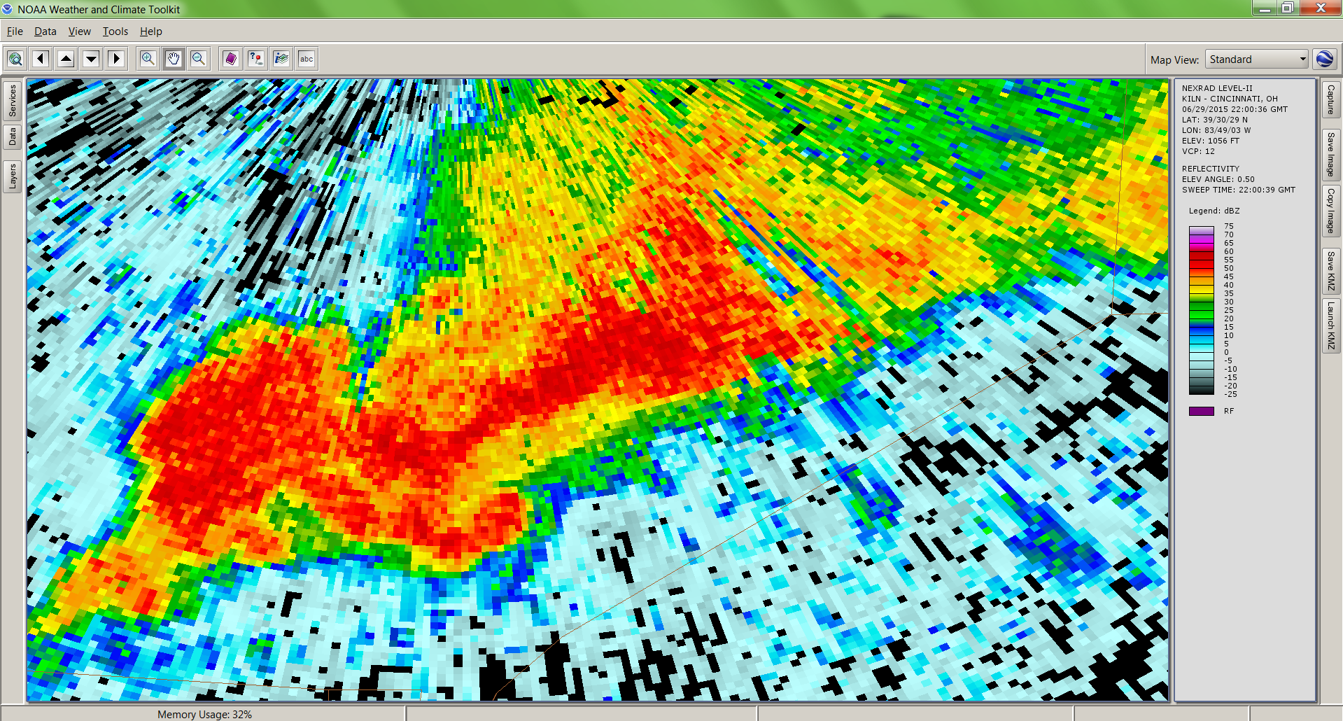
Storm Base Reflectivity at 6:00pm (ILN)

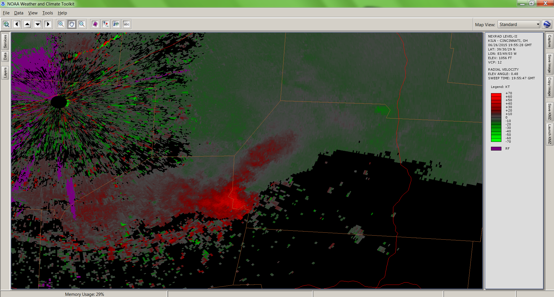
Storm Base Velocity at 6:00pm (ILN)
At 6:00pm EST, the National Weather Service in Wilmington, OH issued a tornado warning for Brown, Clinton, and Highland counties after Doppler radar indicated that the storm was capable of producing a tornado. Within about nine minutes, the tornado warning was cancelled for Brown and Clinton counties, yet remained in effect for Highland county; this due to the movement of the storm out of Brown and Clinton and into highland. Viewing the velocity images, the couplet isn’t notably strong, but the hook echo is extremely impressive.

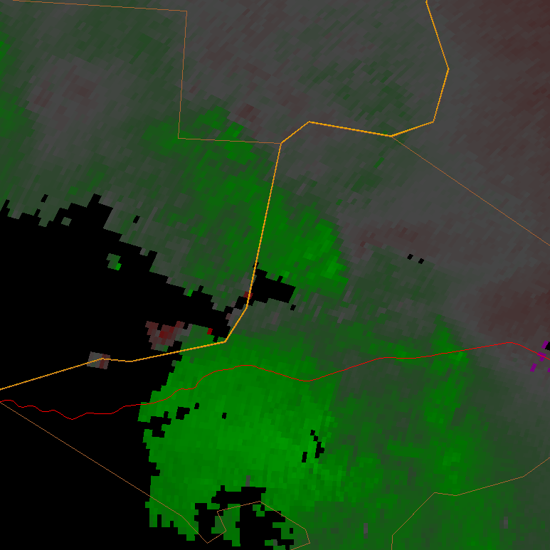
Storm Base Reflectivity at 6:09pm (RLX)
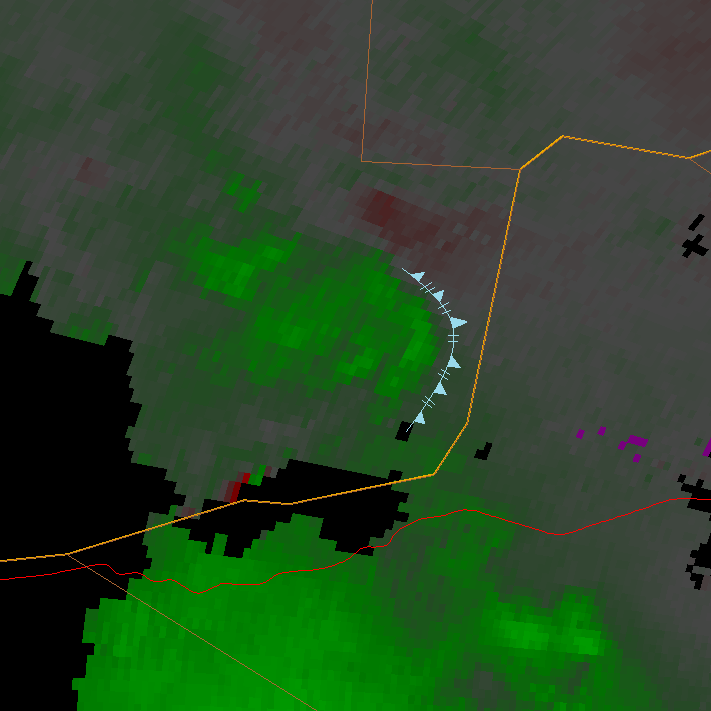
The national weather service in Charlestown, WV issued the tornado warning for Gallia, Lawrence, and Cabell counties at 6:11pm after Doppler radar indicated that the thunderstorm was capable of producing a tornado. The reflectivity and accompanying hook echo associated with this storm is not very impressive, but I was pretty impressed by the velocity images, and therefore have posted several below. Read the captions for the time (in eastern standard time) and note that the couplet disintegrated as the cell moved from Lawrence into Gallia counties, so these images are only from Lawrence County.
The first image is the 6:09pm base velocity, which shows a well defined velocity couplet. The bright red in the middle of the bright green is an error in the radar scan; it should just be bright green. It’s a pretty strong couplet and it is pretty clear as to why they issued the warning a few minutes later at 6:11pm. The couplet basically weakened from that point on until it dissipated. Interestingly, by the 6:40 radar scan the rear-flank downdraft (RFD) begins to manifest itself as a bright green bow of high outflow winds emanating from the couplet (I drew this in the velocity images where it was relevant). These winds go on to overpower the couplet, which is evident in the 6:45pm and 6:50pm radar scans.

Storm Base Velocity at 6:09pm

Storm Base Velocity at 6:14pm

Storm Base Velocity at 6:19pm

Storm Base Velocity at 6:25pm

Storm Base Velocity at 6:30pm

Storm Base Velocity at 6:35pm
Storm Base Velocity at 6:40pm

Storm Base Velocity at 6:45pm
Storm Base Velocity at 6:50pm
* The confirmed tornado in Green County occurred with neither a severe thunderstorm warning, nor a tornado warning.
** The confirmed tornado in Washington County occurred with neither a severe thunderstorm warning nor a tornado warning. The two warnings that were issued for Washington County were issued during storms that occurred on April 9th.
*** This map is made to highlight Ohio counties that have had tornado warnings issued and counties that have had confirmed tornado touchdowns in the 2015 calendar year. Shades of red indicate counties that have had tornado warnings yet have had no confirmed tornado touchdowns yet. Shades of purple indicate counties that have had confirmed tornado touchdowns. In both cases, the bright colors indicate the newest add-ons to this map and are usually the counties mentioned in the discussion above. Darker shades, on the other hand, are used for counties that have had no change in their 2015 tornado statistics. As a second feature, counties that have experienced warnings or touchdowns also have numbers coinciding to the number of tornado warnings and touchdowns. The number that follows a “W” is the number of warnings the county has received, and the number that follows the “T” is the number of confirmed touchdowns that there have been. It is important to remember that each warning issued is counted. If there is a tornado warning on a storm in Stark county, and a second warning is issued for Stark on the same storm, then Stark county would be considered to have two warnings despite there only being one tornadic storm. Likewise, if a single storm drops numerous tornadoes, each tornado will be counted as an individual tornado.