As has been customary over the past few years, yesterday we saw a Christmastime severe weather system roll through the Ohio valley, bringing with it several tornado warnings in southwestern Ohio. Counties including Brown, Clermont, Darke, Miami, Preble, and Shelby all received tornado warnings, and this was the first time that Shelby and Preble counties had a tornado warning issued this year. This afternoon the National Weather Service office in Wilmington, Ohio confirmed a tornado occurred near Arcanum in Darke County, Ohio during yesterday’s storms. It was given an EF0 rating with winds of 77mph. According to the NWS, it was 20 yards wide and traveled along a 50 yard path.
This is the first time a tornado warning has been issued in Ohio since the storms on August 10th. To date we have had 7 confirmed tornadoes, which is a lot fewer than the 19 we had last year. Hopefully we will end our year with no further severe weather in Ohio. Merry Christmas everyone!
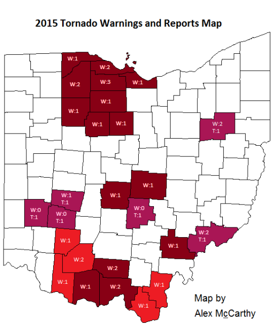
* The confirmed tornado in Green County occurred with neither a severe thunderstorm warning, nor a tornado warning.
** The confirmed tornado in Washington County occurred with neither a severe thunderstorm warning nor a tornado warning. The two warnings that were issued for Washington County were issued during storms that occurred on April 9th.
*** This map is made to highlight Ohio counties that have had tornado warnings issued and counties that have had confirmed tornado touchdowns in the 2015 calendar year. Shades of red indicate counties that have had tornado warnings yet have had no confirmed tornado touchdowns yet. Shades of purple indicate counties that have had confirmed tornado touchdowns. In both cases, the bright colors indicate the newest add-ons to this map and are usually the counties mentioned in the discussion above. Darker shades, on the other hand, are used for counties that have had no change in their 2015 tornado statistics. As a second feature, counties that have experienced warnings or touchdowns also have numbers coinciding to the number of tornado warnings and touchdowns. The number that follows a “W” is the number of warnings the county has received, and the number that follows the “T” is the number of confirmed touchdowns that there have been. It is important to remember that each warning issued is counted. If there is a tornado warning on a storm in Stark county, and a second warning is issued for Stark on the same storm, then Stark county would be considered to have two warnings despite there only being one tornadic storm. Likewise, if a single storm drops numerous tornadoes, each tornado will be counted as an individual tornado.